


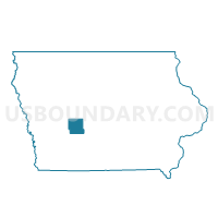
UNION TWP Voting District, Guthrie County, Iowa
About
Outline

Summary
| Unique Area Identifier | 582220 |
| Name | UNION TWP Voting District |
| County | Guthrie County |
| State | Iowa |
| Area (square miles) | 36.45 |
| Land Area (square miles) | 36.45 |
| Water Area (square miles) | 0.00 |
| % of Land Area | 100.00 |
| % of Water Area | 0.00 |
| Latitude of the Internal Point | 41.73259850 |
| Longtitude of the Internal Point | -94.68624480 |
Maps


Graphs
Select a template below for downloading or customizing gragh for UNION TWP Voting District, Guthrie County, Iowa


Neighbors
Neighoring Voting District (by Name) Neighboring Voting District on the Map
- BAKER TWP W/O GUTHRIE CENTER Voting District, Guthrie County, IA
- BEAR GROVE TWP Voting District, Guthrie County, IA
- GREELEY TWP Voting District, Audubon County, IA
- HIGHLAND TWP Voting District, Guthrie County, IA
- MELVILLE TWP Voting District, Audubon County, IA
- ORANGE TWP W/O COON RAPIDS Voting District, Guthrie County, IA
- SEELY TWP Voting District, Guthrie County, IA
- VIOLA TWP Voting District, Audubon County, IA
Top 10 Neighboring County Subdivision (by Population) Neighboring County Subdivision on the Map
- Highland township, Guthrie County, IA (670)
- Baker township, Guthrie County, IA (228)
- Seely township, Guthrie County, IA (209)
- Greeley township, Audubon County, IA (170)
- Viola township, Audubon County, IA (166)
- Bear Grove township, Guthrie County, IA (160)
- Orange township, Guthrie County, IA (130)
- Melville township, Audubon County, IA (117)
- Union township, Guthrie County, IA (117)
Top 10 Neighboring Unified School District (by Population) Neighboring Unified School District on the Map
- Audubon Community School District, IA (3,598)
- Guthrie Center Community School District, IA (2,648)
- Coon Rapids-Bayard Community School District, IA (2,632)